
By: Luis Romo Cedano
 The remains of
the foundations of the world of Jesuit missionaries are scattered along
the banks of the Sinaloa River, in the northwest of Mexico.
The remains of
the foundations of the world of Jesuit missionaries are scattered along
the banks of the Sinaloa River, in the northwest of Mexico.
Sipping a cup of coffee, the historian from Guasave, Ramón Hernández, spoke to me about El Nío, a small village 10 km to the north, and of its famous patron saint, San Ignacio de Loyola.
There is a strange, life-sized, figure of San Ignacio carved out of stone in the El Nío church. The whole carving is the color gray with the exception of the head that is in many colors. Although the figure is dressed, the faithful have placed a cape and a type of embroidered shawl over it.
"When they want it to rain, the people take the figure and bathe it in the river," says the historian; but sometimes obstinate, the saint does not always give the people what they want. "When he does not want it to rain, he does not allow himself to be carried."
San Ignacio may seem a hard saint, but, in a way, El Nío and the hundreds of villages in the northwest of Mexico and the south west of the United States owe their existence to him. In addition, the states of Sonora, Baja California, Sinaloa and to a certain extent, California, Arizona, Durango and Chihuahua would not be what they are today without him, because this saint's children created that whole missionary world as of the 16th century. Precisely those regions around the Sinaloa River where Guasave and El Nío are located were their cradle.
The point of departure of what can be considered the foundation of the Jesuit missionary world is located in the current Sinaloa de Leyva, some 80 km from the mouth of the river. Today, this is one of the most picturesque cities in the northwest of Mexico. Its principal virtue lies in its decrepit atmosphere, its crooked, narrow streets and in the infinite number of old 19th century and beginning of the 20th century houses with their high roofs, elegant cornices, and Roman patios.
The Jesuits' exploits started here in 1591 with the arrival of Fathers Gonzalo de Tapia, a Spaniard, and Martín Pérez, a Mexican. In those days, Sinaloa de Leyva used to be called Villa de San Felipe y Santiago de Sinaloa, and it was no more than a sad memory of the failed attempts to conquer by the Spaniards.
Martín Pérez started preaching downstream while Gonzalo de Tapia went north. The latter was short, had poor eyesight, was a bit of a joker, and had a great gift for languages. After being in Sinaloa for just one month, he was able to make himself understood in two indigenous languages. He immediately began to preach the Christian Gospel through catechisms and hymns, but his labor caused a great deal of discontent among the local shamans, to the degree that one of them, Nacaveva, ended up killing him and eating him for supper. But de Tapia had already sown the seed. The humble stick and mud hut he had built with Pérez in Villa de San Felipe y Santiago (of which naturally nothing remains) later became the Jesuits' regional center. The Compañía established a big church and a school there for the education of the Indians, as well as copious granaries, a pharmacy and an infirmary. However, very little of what the Jesuits built or made remains.
 The
solidity of the socio-economic work of the Compañía, together with the
nearby mineral wealth -mainly from Chínipas in the current state of Chihuahua-
left the village in a relatively prosperous situation.
The
solidity of the socio-economic work of the Compañía, together with the
nearby mineral wealth -mainly from Chínipas in the current state of Chihuahua-
left the village in a relatively prosperous situation.
Towards the end of the 18th century, Sinaloa de Leyva had a population of about four thousand and was the biggest town in what is today Sinaloa. But it still grew to reach a population of ten thousand by the end of the 19th century. As a testimony of its vigor, we have the aforementioned mansions, but the expulsion of the Compañía de Jesús undoubtedly contributed to this village loosing its claim of being the main town in the territory.
EL NÍO'S ENEMIES
Villa de San Felipe y Santiago was not, strictly speaking, a mission town; it was, rather, a Spanish villa. However, missionaries did go to Cubiri, 7 km to the south, and to Bamoa, 18 km away. Bamoa also has colonial houses and buildings, but it lacks the ancient atmosphere. It also has curious origins. History books tell us that is was founded by Álvar Núñes Cabeza de Vaca, the explorer who went on one of the most fantastic journeys in history, between Louisiana and Sinaloa. In Sonora, he was joined by a group of Pima Indians who accompanied him on the final part of the trip. When they found some other Spanish soldiers near the Sinaloa River in 1536, the Pima escorts wisely kept their distance from the soldiers who formed part of the troops of the fearful Nuño de Guzmán and founded the village. Later on, at the end of the century, Martín Pérez, Hernando Santarén and the Portuguese Pedro Méndez arrived at the newly founded village and opened a mission.
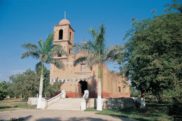
The Jesuit church in Bamoa, like the others in the riverbank towns and villages, was destroyed by the flooding of the Sinaloa River in 1770. The current church appears to have been built in the 19th century, although it was remodeled during the 20th century.
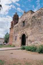
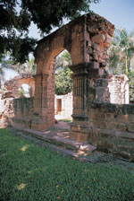
El Nío, 10 km to the south, is the village that suffered most from the dismantling of the Jesuit missionary system. In order to understand its history fully, it has to be appreciated that today it consists of two villages, El Nío and 2 km to the south, Pueblo Viejo. The first mission in El Nío, established in 1595 was located in the latter. The Jesuits began building a large church in about the middle of the 18th century, but the river flooded in 1758 and the works, which had advanced well, had to be abandoned. The remains of this incomplete church still stand and are some of the most impressive in the region.
After the flood, the village was re-founded upstream, although not the whole population went to the new site. Construction on another church started next to the current church in El Nío, but, as though the place was jinxed, it was struck by another calamity. On this occasion, Carlos V outlawed the Compañía de Jesús from the entire Spanish empire in 1767, leaving the missions abandoned yet again.
The current church in El Nío was built in the 19th century and is the location of the already mentioned figure of San Ignacio that was made prior to the village's move.
THE EXEMPLARY GUASAVE MISSION
El Nío is 10 km from Guasave and the area irrigated by the Sinaloa River is becoming increasingly widespread. The long irrigation canals that have made this into one of the richest agricultural areas in the country were dug at the beginning of the 20th century, but necessarily, they go back to the agricultural prosperity of the times of the missions. Many different types of crops were introduced during the 16th century, including garbanzo beans and garden produce.
Apart from being centers of diffusion of the Christian faith, the missions also had economic and educational functions, and they managed to grow more than sufficient crops for local consumption. The excess was sold in the nearby sierras, or was used to feed the new missions founded further north or on the west coast of the Sea of Cortez during their first years of existence.
THE END OF THE MISSIONS
The last mission village along the Sinaloa River is Tamazula, 18 km south of Guasave. We had the opportunity of speaking to Don Hermes González Maldonado at the community museum there. Don Hermes knows the history of the town better than anyone else does. He explained to us that Tamazula is one of the oldest permanent settlements in the region: the Indians were established there long before the arrival of the Jesuits, and it appears that the place was visited in about 1530 by the sea expedition led by Don Diego Hurtado de Mendoza.
 The
mission in Tamazula, also built in the 16th century, was founded
by Father Clerecis, and similar to the one in Guasave, was downed by strong
winds and cyclones. There is nothing left in Tamazula to remind us of
the times of the Jesuits, except for Don Hermes's story.
The
mission in Tamazula, also built in the 16th century, was founded
by Father Clerecis, and similar to the one in Guasave, was downed by strong
winds and cyclones. There is nothing left in Tamazula to remind us of
the times of the Jesuits, except for Don Hermes's story.
We
left the underbrush and the hills behind us on the last leg of our journey
to Playa Las Glorias, just by the mouth of the river. On the way, we saw
irrigation canals, plenty of cattle, ostrich and shrimp farms, crops growing
in fields and straight roads. San Ignacio's children would have enjoyed
this sight as well as the spectacular sunsets at Las Glorias (the most
beautiful we had ever seen), which can today be peacefully enjoyed by
tourists.
IF YOU'RE
GOING TO THE MISSIONS ALONG THE SINALOA RIVER.
The city of Guasave is located on the border of the México-Nogales Highway, which, at that level, has turned into Federal Highway 15. You can take public transport from there to any of the mentioned villages. If you are driving, take any of the following routes: NORTH: You will find signs to the highway that will take you the 40 km to Sinaloa de Leyva in Guasave. However, the road going to Bamoa Pueblo, El Nío and Pueblo Viejo runs parallel to the other, about 2.5 km southeast of it. Depending on your travel plans, ask for this road in Guasave or in Sinaloa de Leyva. SOUTH: To get to Tamazula, you have to follow the signs in Guasave and take the paved highway to Las Glorias. After ten kilometers, in El Cubilete, turn left (towards the southeast); Tamazula is 8 km of straight road from that junction. To go on to Playa Las Glorias, take the dirt track opposite the church in Tamazula; this will take you to Zerote and La Brecha. At this last town, you will again get on to the paved highway. The beach is only 13 km from this point.
Source: México desconocido # 277 / March 2000